Needless to say, my friend Gary and i survived our backpacking expedition in the Mount Baldy Wilderness. It was a great trip, though exhausting. It wasn't the length of the hike so much as it was the steep up (or down) inclines and the altitude. At 10000 or more feet it's hard to catch your breath. The Mount Baldy Wilderness is a roughly triangular patch of forest, river, and mountain of about 7700 acres. We hiked a route which took us up the western trail to the summit of Baldy (or as close as you can get to it), down the eastern trail, and then across the base of the triangle on a 3.5 mile crossover trail.
The initial trail head is at about 8700 feet and you go up only gradually for the first few miles. The trail at this point follows one fork of the Little Colorado river, through meadows and stands of aspen, Douglas fir, and Ponderosa pines. It's incredibly beautiful country, especially this summer because they've had significant rain and everything is green and flourishing. One could point the camera in almost any direction and get a good photo.

We both felt pretty good through these first few miles, even with the heavy packs. The weather was perfect, sunny skies and just a bit cooler than ambient. Soon though the trail started to head sharply upward and we slowed down quite a bit. We stopped near a stream to get some water and food and take the packs off, but at the time we had no idea how far we were from the summit. As we approached 10000 feet i started to suck wind pretty hard and Gary was having some pain in his hip. My rule of thumb for backpacking has always been that you can make around 2 mph uphill and 3-4 downhill, but we were probably closer to about 1 mph on these sections. After a series of switchbacks that ran up the side of a ridge, it flattened out a bit. Eventually we came to an interesting bench of rock poised right at a saddle point on the ridge so that there were views in both directions. Although it was beautiful, i nicknamed it The Bench of Desperation, since we felt like we'd been walking for a long time and we had no idea how far we were from the summit.
We were probably only about a mile out at that point, but as the altitude approached 11000 feet, it was pretty hard going. Gary started a pattern of walking 100 steps and then stopping for a rest. We counted unique species of mushrooms. It was eerily quiet-- no wind, no birds, no scurrying wildlife or protective squirrels, not even a cricket chirping-- yet the sky was clear except for a few isolated rain clouds. Finally, we reached the border of the wilderness area and the Apache reservation, which is as close as you can get to the summit of Mount Baldy if you're not Apache. Gary's GPS put the altitude at 11,164 feet.
We rested for several minutes, drank some water and ate some trail mix. Then we started down the East trail. The character of the trail was almost immediately different, and i don't just mean its relative downness. There seemed to be more water, so the flora was markedly different. We also found a spring flowing from the rock just below the trail about 1/2 mile down. The most interesting site on this part of the trail (and perhaps the whole hike) is the debris from an airplane crash. I don't know enough about airplanes to identify anything from the wreckage, but it was clearly a large plane that hit the mountainside hard and scattered the debris widely. On the internet, i found evidence for both a DC-3 crash in April of 1937, and for a B-24 crash in 1942. The latter seems the more likely candidate, because there was an unmistakable Air Force marking on one part of the plane, and this was definitely a military aircraft.

A short distance further down the trail we came to a rocky promontory that gave us a great view of the whole wilderness area and points beyond. It was both a gorgeous view and also a good excuse to drop our packs and stop walking. After a bit we loaded up again and started down the trail, keeping our eyes open for a decent place to spend the night. Sunset was still more than an hour off, but we figured it would get dark early since we were on the east side of the mountain. We finally found a relatively flat spot with a fire ring, so we made camp and tried to start a fire. Turns out that it's hard to start a fire with wood that's been rained on for several weeks. We managed to get a small blaze going, and Gary fired up his WhisperLite stove to boil some water. We used the water to reconstitute some red beans and rice, which, even though slightly crunchy, was very good after a full day of pack mule duty.

In relative terms, it wasn't a bad night in the tent. It remained abnormally quiet, but we both managed to get a little sleep and it didn't rain. At about 5:30 am i finally heard a few birds signaling the impending dawn. I got up and tried to start a new fire, but i just couldn't keep it going. Gary got up a bit later and boiled some more water for oatmeal and coffee. He checked the GPS and realized that we'd probably spent the night on the Apache reservation, onto which the trail wanders for one short section. We'd planned to hang around the camp for a while, but we decided we should probably move on.
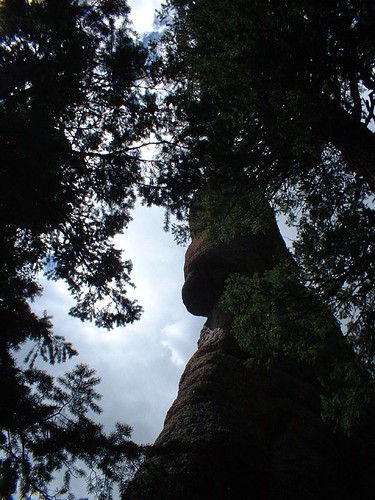
The next mile or so was relatively flat, sort of along a contour line at around 10400 feet. At one point the trail ran across an open area of bare rock that gave us more views of the surrounding valleys. This trail, unlike the west trail which featured primarily trees, is characterized by geology. We reached a series of switchbacks that went down a ridge through some of the oddest and most fascinating rock formations i've ever seen. There were towers of rock that looked like giant cairns of boulders built by giants. There were caves and ledges in the cliff faces above us. It looked almost as if the rock had been worn away by flowing or receding water, but this would have happened long ago since this is still way above the river.
Finally we came out into open meadow again, running along the other fork of the river. After a mile or so of this relatively flat terrain, we came to the eastern trail head. Fortunately, Gary had the presence of mind to realize that we could leave our packs here for the hike on the crossover trail, and then drive back when we reached the other trailhead. That was good, because the crossover trail would have sucked with the extra weight. It was a nice little trail, though not as well maintained as the other parts, but we were both too tired by this time to enjoy it much.
Backpacking is a strange pasttime for me in the sense that i'm alway really excited to get started when i start, and always really happy to finish when i stop. It's not like watching a movie, or even playing most sports, because instead of period of relatively consistent but predictable enjoyment, backpacking tends to give you periods of pain or exhaustion in exchange for moments of unexpected, transcendent joy. I can't count the number of times over the years when i've been right at the moment of thinking "Why the hell am i doing this to myself?" and then i'll come around a corner and see a view (or an animal or a tree) that makes me feel lucky to be alive. It also make me appreciate civilization, though the effect is temporary.

No comments:
Post a Comment